
Chettimedu Sakthi Amman Koil Street Pond
Chettimedu Sakthi Amman Koil Street Pond is located on the west side of Andarkuppam - Redhills Road. Since the pond is at the end of the street where the temple of Sakthi Amman temple is located, damage by the encroachments and misuse was tolerable. Now the pond is fully restored under the Chennai Smart City project funds.
AREA:1011.715 Sq.mtrs ZONE: 2 DIVISION:17
This pond is located in Division 17 of Zone 2 and is on the Andarkuppam - Redhills Road. It is located to the West of the road. The Sakthiamman Temple is located nearby the pond. The pond is located at North Latitude 1311'3.05" and East Longitude 8013'18.07.
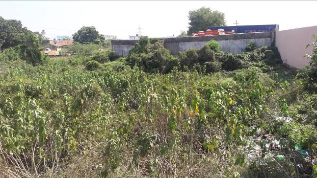
The pond is irregular in shape. There is no water in the pond during the time of survey. There is no revetment or steps available in the pond. No structural component such as inlet or surplus weir could be located.
At present, there is no specific catchment to the pond but for its own in-situ catchment. But there is scope for road water diversion into the pond. The area around the pond is urbanized. There is an industry in the southern side of the pond with its compound wall forming the southern boundary of the pond. The pond in the northern side is partly encroached by a commercial establishment. The bund and water spread area of the pond is fully covered with dense bushes. There is no inlet or outlet to the pond provided. Based on the interaction with the local community, it is inferred that there will be water in the for about 5-6 months in the past; at present the pond is dumped with solid waste; also sullage is diverted from the nearby commercial establishment.

There is no storm water drain available nearby. The surface run off follows the general slope and does not get diverted into the pond. In order to assess the present extent of the pond, depth and the length of the bund, Total Station Survey (TSS) was conducted in the pond. Based on the Total Station Survey output, it is inferred that the total area of the pond is 1,049.122 sq.m and the total length of the bund is 140m. The average depth of the pond is about 2m.
The imagery extracted from google earth on 21.03.2016 and 31.08.2001 is presented below shows urbanization happening all around the pond with possible encroachment happening in the north eastern side of the bund and water spread area.

Google Image of the pond as on 31.08.2001 (LEFT) and 21.03.2016 (RIGHT)
The total storage of the tank in its present condition is estimated at 2098.24 cu.m Based on run off modeling, there will be water available in the pond for almost 119 days in a year. At no point of time,

Thrust Geoconsultants Private Limited, Chennai.
the pond overflows in a normal rainfall year. The total inflow to the tank in a normal rainfall year is estimated at 1880.9 cu.m; the total groundwater recharge will be 1231.17 cu.m.
During years of excess rainfall ie ., for the estimated period of 2005 the actual volume stored in the tank after losses due to evaporation and recharge is given in the following graph.

Even in a heavy rainfall year, the pond does not over flows; The total inflow to the tank in an excess rainfall year is estimated at 3947.48 cu.m; the total groundwater recharge is 1248.45 cu.m.
Inference: Hence it could be inferred that the pond acts as a groundwater recharge source and recharges about 1100 KL per annum in a normal rainfall year. Hence by rejuvenating the pond, it will recharge 1100 KL every year and will help in sustaining the groundwater sources in the region.
Based on the field observations and inferences, followed by the data analysis, following were the list of activities proposed for renovating the Pond.
- To start with, the pond can be desilted and cleaned in the water spread area.
- The bund need to be trimmed, strengthened;
- Revetment to be provided on all sides of the pond.
- Bush clearance all around the pond and provision of a pathway all around the pond to a width of 2m and properly fenced.
- Surface run off from the road can be checked and diverted into the pond through a filter chamber.
- A recharge well of 1.8m in diameter to a depth of 3m can be provided in the pond to facilitate groundwater recharge.